Latest: The might of Cyclone Nilofar has gained momentum as it barrels down towards Oman, with a mere 550km or 320 nautical miles separating the centre of the storm to the nearest point on the coast, according to the country’s Met Department.
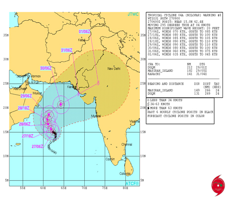
The US Navy’s Joint Typhoon Warning Centre places this as Oman’s Masirah Island, adding that the centre of the storm is currently ‘a 10 nautical mile [18.5km] cloud-filled eye and deep connective feeder bands wrapped tight into the well-defined low level center’.
Wind speeds are averaging at 80 knots or nearly 150kmph, with Oman issuing a marine warning, advising all boats to return to the coast.
The current trajectory of Nilofar is critical for the country over the next 10 hours as the deep depression – upgraded to a ‘very severe cyclonic storm’ – moves northwest before it is expected to re-curve northeast and make its way towards Pakistan and India.
Oman: The Oman Meteorology Department has reiterated the cyclone is not likely to make landfall, even though high winds, rainfall and rough seas are forecast over the next 24 hours.
The Met office said in a statement: “Most numerical weather predication models still forecast the cyclone to approach Al Wustah and Southern Al Sharqiah coasts without landfall.”
The office further stated: “The cyclone is likely to move northwest on Tuesday and Wednesday; the centre of the cyclone is expected to be between 350km to 450km from Oman’s Arabian Sea coast at the closest. Moderate to heavy rains likely over the governorates of Al Wusta and souther Al Sharqiya.”
The Met office also issued a marine warning, citing that the Arabian Sea and the Oman Sea are expected to be 'very rough'.
It added: “The Public Authority for Civil Aviation appeals to fishermen and sea to goers to avoid venturing to the sea along the coasts of Oman.”
Pakistan: Pakistan’s Met department has placed the cyclone 1,120km southwest of Karachi and 1,030km south of the port of Gawadar.
In a statement, the Met office said: “The cyclone would continue to move in northwest direction today [Tuesday] with a speed of 6kmph and is expected to re-curve northeastwards (towards adjoining coastal areas of Lower Sindh and Indian Gujarat) on Wednesday.
“At present the estimated central pressure of the cyclone is 990 hPa [Hectopascals or the standard for measuring barometric pressure] and the average sustained wind speed around is 90-100, gusting up to 110 Knots [203kmph].”
The country is bracing itself for thunderstorms and very heavy rainfall in Lower Sindh, including Karachi, the coastal areas of Balochistan from Wednesday evening to Friday.
The storm surge will be accompanied by strong gusty winds.
India: The Indian Met Department’s morning update has placed the storm 1,110km southwest of Naliya, Gujarat, adding: “It would move northwest during the next 12 hours and then gradually curve northeast and cross north Gujarat and adjoining Pakistan coast around Naliya by November 1 forenoon.
“However, as the system would come closer to Gujarat coast, it would weaken and the cross the coast as a cyclonic storm.”
Under the influence of this system, the Met office forecasts rainfall at most places on the belt, with isolated heavy to very heavy falls along the coastal districts of Saurashtra and Kutch from October 31, late evening.
Squally wind speeds will reach 45-55kmph gusting to 65kmph along and off Gujarat coast from October 31 evening and would reach 80-90kmph, gusting to 100kmph at time of landfall.
Airlines: Those travelling over the next 48 hours to and from the Gulf to Oman, India and Pakistan are advised to check with their airlines for a possible change in schedule due to the storm. Emirates, Etihad Airways, Qatar Airways and Indian carrier Spicejet have stated they are monitoring the situation.
Earlier report:
UAE residents planning to head to Oman over the next two days may need to alter their travel schedule as Cyclone Nilofar looms 880km off the coast of Salalah, bringing high winds and rainfall to Masirah Island and Duqm.
The US Navy’s Joint Typhoon Warning Center (JTWC) has placed the cyclone 406 Nautical Miles off the coast of Masirah Island, with the Indian Meteorological Department upgrading the deep depression to a ‘Very Severe Cyclonic Storm’ as it reaches off the coast of Oman with wind speeds of 150kmph.
The UAE’s National Center of Meteorology and Seismology (NCMS) has reiterated Cyclone Nilofar will not impact the country, but could bring ‘accelerated winds’ up to 25 knots on Wednesday and Thursday.
Meanwhile, Emirates, Etihad Airways, Qatar Airways and Spicejet have stated they are monitoring the situation. However, no flights have been affected as yet to Oman, India and Pakistan.
In a statement, an Etihad spokesperson said: “Etihad Airways continues to monitor the progress of Cyclone Nilofar and will modify our flight routings to circumnavigate the area if required.”
A spokesperson with NCMS told Emirates 24|7: “There will be no direct impact of Cyclone Nilofar on the UAE, but the country could expect accelerated winds on Wednesday and Thursday reaching up to 25 knots.
“There could also be distinct cloud cover on those days, with a possible chance of the weather pattern giving rise to convective clouds that could bring rainfall to Al Hajjar mountains and the eastern coastline of UAE.”
The weather pattern could temporarily see a drop in temperatures between 2-3 degrees Celsius.
The spokesperson stated that a marine warning has also been issued for the Arabian Gulf and the Oman Sea.
“We are issuing a warning for rough seas for those days, with waves reaching up to seven feet in wake of the deep depression that will change to a ‘Very Severe Cyclone’ over the next few hours.”
However, the NCMS has stated following the Cyclone Nilofar’s current trajectory, it is unlikely to make landfall in mainland Oman.
In a statement issued late Monday, NCMS added: “Through the current weather maps and satellite images of synthetic plus meteorological reports from the competent regional centres, the tropical storm is currently stationed at latitude 14.8 north, longitude 62.0 east, as is currently 875km off the Omani coast, with surface wind speed and estimated about his position between 100-110kmph.”
Oman braces for rainfall
Oman’s Met office has forecast fresh winds and rainfall in Al Wusta, Dhofar and Al Sharqiyah on Tuesday and Wednesday.
Muscat is expected to receive isolated showers by the afternoon due to the formation of convective clouds over Al Hajjar mountains.
The country has also issued a marine warning, with waves expected to reach up to 13 feet in the Oman Sea.
Several residents in the country are stocking up on food, water and petrol in preparation of a possible impact to the mainland.
Abdul Kalam, a resident of Qurum, said: “A lot of our neighbours are stocking up on water and canned food. It’s just taking extra precautions. None of us have forgotten Cyclone Gonu.”
Cyclone Gonu hit the coast of Oman in June 2007, resulting in extensive damage to property and hundreds being evacuated from coastal areas.
Pakistan
Pakistan’s Met office has also issued a marine warning, in effect from Wednesday until Friday, with all coastal operations to cease as Cyclone Nilofar’s trajectory sees it spin Northeast by October 30.
In a statement, the Met office added: “Tropical Cyclone (Nilofar) in the Arabian Sea has intensified into a Severe Tropical Cyclone with an intensity of T3.5.
“The cyclone is likely to move further west-northwest ward (towards Oman Coast) with a speed of 8kmph during next 24-36 hours, then it would re-curve northeastward (towards adjoining coastal areas of Lower Sindh and Indian Gujarat).”
Under the influence of this cyclone, widespread thundershowers with isolated heavy rainfall, accompanied by strong gusty winds, are expected in Lower Sindh, including Karachi and Coastal Areas of Balochistan during Wednesday (night) to Friday.
The sea conditions along Pakistan coast would be rough to very rough from Wednesday evening to Friday.
The statement added: “Fishermen of Sindh and Balochistan are advised not to venture in open sea from Wednesday to Friday.
“The fishermen who are already in the open sea are advised to return to coastal areas before Wednesday.”
India
According to the Indian Met Department’s late evening Monday bulletin: “The very severe cyclonic storm, Nilofar would move initially north-northwest during next 24 hours and then re-curve northeast and cross north Gujarat and adjoining Pakistan coast around Naliya by October 31 morning.
“However, as the system would come closer to Gujarat coast, it would weaken and cross the coast as a severe cyclonic storm.”
India’s Met office has also issued an alert for the coastal districts of Saurashtra and Kutch from the morning of October 30, with rainfall at most places with isolated heavy to very heavy showers.
Squally windspeeds reaching 45-55kmph gusting to 65kmph would commence along and off Gujarat coast from October 30 morning and would intensify to 100-110kmph gusting to 125kmph at the time of landfall.
The statement added: “Sea condition along and off Gujarat coast will be rough to very rough from October 30 morning and would become very high from afternoon.”
The Met office is estimating extensive damage to huts with thatched roofs. Minor damage to power and communication lines due to uprooting of large avenue trees and flooding of escape routes.
Fishermen out at sea along and off Gujarat coast have been asked to return to coast, with a total suspension of fishing operations. Meanwhile, coastal hutment dwellers are to be moved to safer places. People in affected areas have been warned to remain indoors around landfall time.